
North Carolina Faces Brief Severe Storm and Isolated Tornado Risk Friday Morning as Remnants of Arthur Push Through Central and Eastern Counties
CENTRAL NORTH CAROLINA — Remnants of Arthur, currently positioned over parts of Georgia and South Carolina, are forecast to move into North Carolina overnight into Friday morning, bringing pockets of heavy rainfall, gusty winds, and a brief, isolated risk of severe storms with damaging winds and an isolated tornado threat across Central and Eastern portions of the state.
Storm System to Track Through Mountains Into Central and Eastern NC
The system will work through the region over the next several hours, moving from the mountains and foothills through Central and Eastern North Carolina by Friday morning into midday. The primary impacts expected from this system are rain and gusty winds across the affected areas.
Isolated Severe Storm and Tornado Risk for Eastern Counties
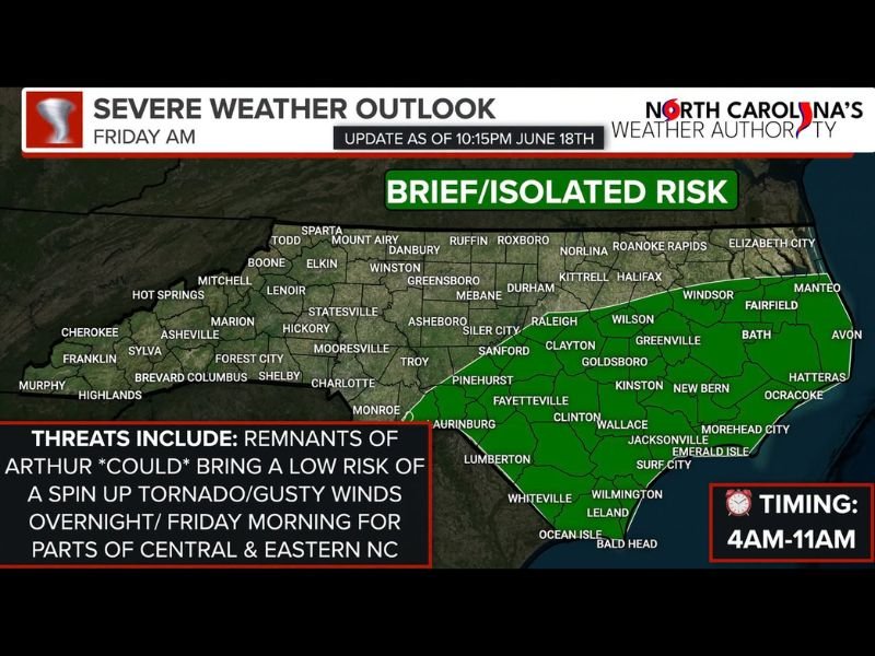
A brief, low-end isolated risk exists for a strong to severe storm capable of producing damaging winds or a brief tornado as the circulation moves through parts of Eastern North Carolina, driven by wind shear in the atmosphere. The risk area, highlighted in green, spans a wide swath of the state including the following counties and cities:
- Mountains/Foothills: Sparta, Boone, Mount Airy, Elkin, Marion, Lenoir
- Central NC: Winston-Salem, Greensboro, Statesville, Asheboro, Charlotte, Raleigh, Durham
- Eastern NC: Fayetteville, Wilson, Goldsboro, Kinston, Lumberton, Wilmington
Timing Window Runs Roughly 4 AM Through Lunchtime Friday
| Timeframe | Detail |
|---|---|
| Start | Around 4:00 AM Friday |
| Peak Threat Window | Pre-dawn through midday |
| Western Areas | Earlier timing within the window |
| Eastern Areas | Later timing within the window |
| End | Most rain cleared by Friday afternoon |
Residents within the green risk area are advised to have a reliable way to receive Tornado Warnings overnight, including NOAA Weather Radio or smartphone emergency weather alerts, before going to bed.
Gusty Winds Likely to Impact Coastal Ferries Friday
Beyond the isolated severe risk, gusty winds are expected Friday, particularly during the morning hours across the Eastern and Coastal areas of North Carolina. These winds could lead to impacts on ferry operations in coastal regions.
Sunshine Returns Friday Afternoon
Most remaining rainfall is expected to clear the state by Friday afternoon, with sunshine returning behind the system as it exits the region.
Stay tuned for further updates as this system continues to develop overnight and into Friday.